Get Ready for INTERGEO 2024 in Stuttgart with Us!
We’re gearing up for an exciting event this September – INTERGEO 2024 in Stuttgart! As an exhibitor, we’re eager to connect with industry peers and geoinformation enthusiasts. This event promises to be a blend of networking opportunities, trendspotting, and a deep dive into the evolving landscape of geoinformation technology.
Highlighting our latest solutions

1. Pythagoras CAD Software
Our Pythagoras CAD software is a game-changer for professionals across various sectors. Whether you’re in surveying, indoor mapping, or UAV operations, this software offers intelligent algorithms that effortlessly transform diverse geodata into CAD-ready deliverables. From total stations and GPS instruments to UAVs and laser scanners, Pythagoras Software streamlines data processing, making complex tasks feel like a breeze.

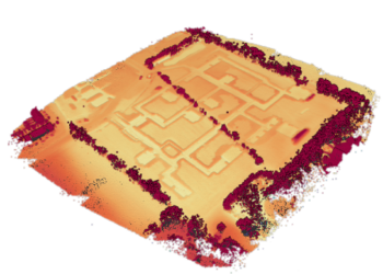
2. Pointorama Platform
Looking to take your point cloud projects to the next level? Our Pointorama Platform is the answer. Beyond being a point cloud platform, Pointorama sparks innovation and fosters collaboration. With our cutting-edge technology, you can expect more than just processing – you can expect transformation.
Save the date
We can’t wait to see you there!
Let’s connect!
INTERGEO 2024 isn’t just an event; it’s a collaborative journey towards shaping the future of the geoinformation industry. As exhibitors, we’re excited to be part of this dynamic community and contribute to its growth.
We invite you to join us at our booth to explore our products, discuss industry trends, and share insights. Whether you’re a seasoned professional or new to the geoinformation world, there’s something for everyone at INTERGEO 2024.
Related articles
LiDAR: How the use of laser pulses can lead to accurate landscape analysis
When I ask you to think about laser pulse technology, you’ll probably envision some big satellite or space station. But what if I tell you that nowadays, you can even find a laser scanner in your Iphone!
In this article we’ll tell you all about LiDAR, and why you probably should be using it.

How to capture a point cloud
Point clouds have emerged as a crucial tool in various industries, revolutionizing the way we perceive and analyze spaces. In this article, we’ll look into the process of creating point clouds to explore three main acquisition methods.

Choosing the right point cloud format
In this blog post, we’ll delve into the world of point cloud formats, offering some insights into each. We’ll also provide personalized advice on which format might suit you best.