How it all started
Back in 2011, we began our journey as a small team, passionate about creating easy-to-use tools for the geospatial industry. We were driven by a desire to make a positive impact in this ever-evolving field.

Pythagoras
Our pioneering product, Pythagoras, is a carefully designed CAD tool crafted for the surveying field. Users employ this software for precise calculations and to create high-quality plans. The solution stands out because of its distinctive set of tools and a very short learning curve.
Pythagoras shines in its compatibility with all standard formats and seamless integration with major equipment brands—encompassing total stations, GPS devices, and scanning systems. This ensures that users can easily combine traditional survey data with point clouds within the software.
Over time, Pythagoras has gained an excellent reputation among thousands of surveyors worldwide. Its ease-of-use and exceptional customer support have made it a highly valued tool within the industry.

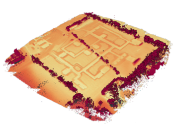
Pointorama
As scanning technology advanced, it became easier to generate a lot of point cloud data. However, dealing with, visualizing, processing, and sharing this expanding data posed significant challenges.
Fueled by our enthusiasm (and perhaps a bit of coffee and donuts), we set out on a mission to create Pointorama. Our aim was crystal clear: design a powerful yet user-friendly platform that could handle large and complex datasets without the need for costly hardware or software.
Thus, Pointorama was born—an innovative SaaS platform packed with tools for point cloud processing, visualization, and analysis. We dedicated extensive effort to ensure it’s easy for users, focusing on simplicity, adaptability, and ease of sharing.
Today, Pointorama strives to be the top choice for professionals in the survey industry. We’re proud of the journey that led us to this point and eager to keep pushing the boundaries of what’s possible in this continually evolving industry.
What we believe in
Reliability
During the task of processing point clouds we consider reliability to be the key value of our platform. Pointorama ensures that users can always depend on it to function as intended, providing seamless and uninterrupted processing of point clouds.
Efficiency
Pointorama prioritizes efficient processing of point clouds. We do this by in-house development of our platform and a constant optimization of AI-algorithms. This ensures users to quickly and easily process their data and focus on other important tasks.
Ease of use
Point cloud processing can be a complex task, so Pointorama prioritizes ease of use. This includes features like intuitive interfaces, clear instructions, and tutorials and help documentation to guide users through the process.
Shareability
Pointorama allows users to easily share their point clouds with others. This provides features like collaboration tools, the ability to export point clouds in different formats, and easy sharing possibilities.
Related articles
LiDAR: How the use of laser pulses can lead to accurate landscape analysis
When I ask you to think about laser pulse technology, you’ll probably envision some big satellite or space station. But what if I tell you that nowadays, you can even find a laser scanner in your Iphone!
In this article we’ll tell you all about LiDAR, and why you probably should be using it.

How to capture a point cloud
Point clouds have emerged as a crucial tool in various industries, revolutionizing the way we perceive and analyze spaces. In this article, we’ll look into the process of creating point clouds to explore three main acquisition methods.

Choosing the right point cloud format
In this blog post, we’ll delve into the world of point cloud formats, offering some insights into each. We’ll also provide personalized advice on which format might suit you best.
Want to know more?
Whether you have a question, feedback, or just want to say hello, please don’t hesitate to get in touch with us. We look forward to hearing from you and starting a conversation!
Contact us